


Description
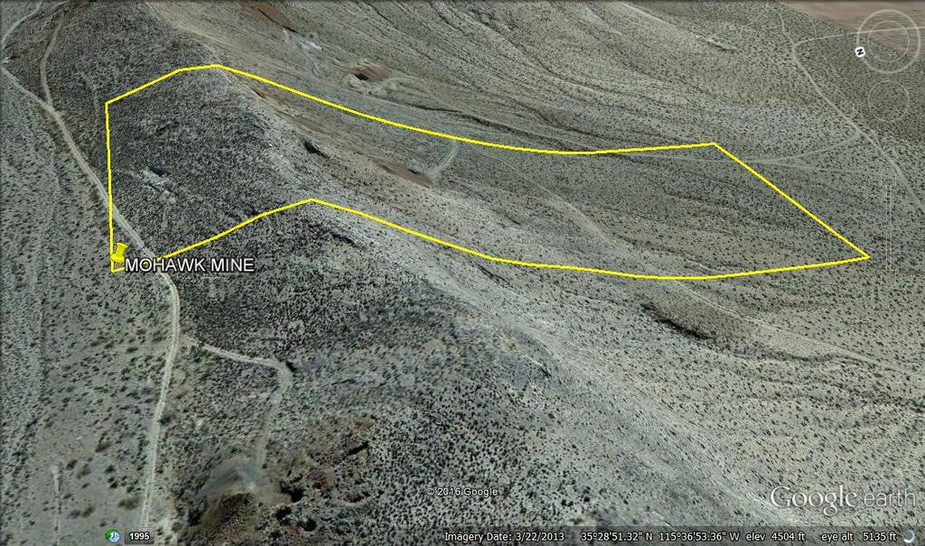
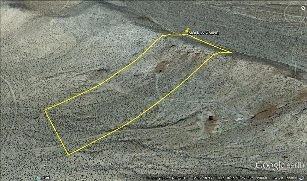
MOHAWK MINE
CAMC313828

20.66 Acre Lode Mining Claim in the Historic Ivanpah District, San Bernardino County, CA

Bureau of Mines Regist’d, 206 oz Gold, 92,802 oz Silver

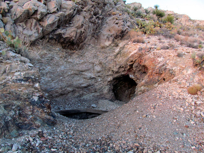
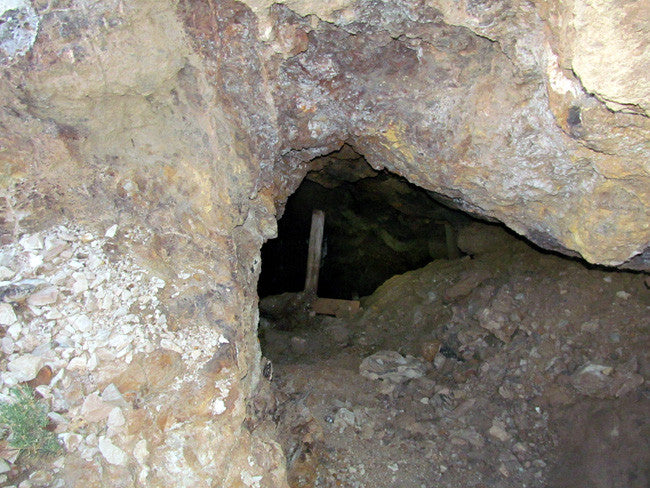
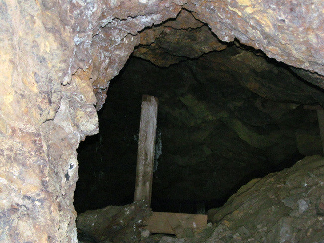
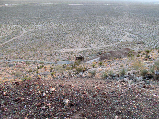
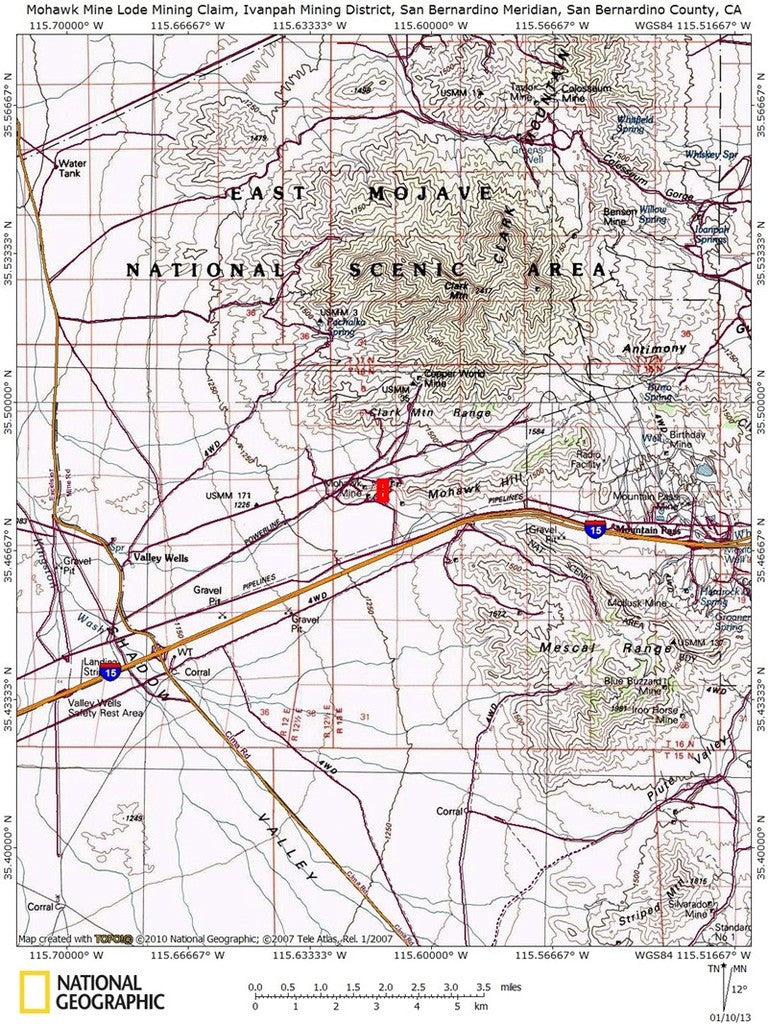
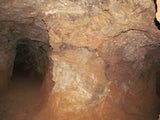
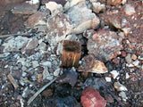
The Mohawk Mine lies within the southwest portion of the Ivanpah Mining District, approximately 3 km east-northeast of the Cima Road exit from I-15. As you drive toward the mine workings, clearly visible above a series of tailings piles, you’ll note the "dirty brown" coloration of the rock immediately above the workings. This is the result of circulating groundwater which extensively oxidized the primary sulfide mineralization during Tertiary to Recent time. While the coloration is due to the presence of several different mineral phases, most are forms of hydrated iron and manganese oxide.
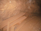
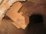
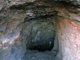
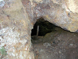
The Mohawk Mine was worked briefly during World War I (19161918). Three hundred tons of hand cobbed ore were shipped yielding 4 oz. of gold, 20,000 lbs. of copper and 250,000 lbs. of lead. The property lay idle until its acquisition in 1942 by the Ivanpah Copper Company. Production records are incomplete, but from 1942 to 1952 Ivanpah Copper reported the shipment of 16,700 tons of ore which produced 206 oz. of gold, 92,802 oz. of silver, 183,600 lbs. of copper, 2.9 million lbs. of lead and one million lbs. of zinc (Hewett, 1956). Mapping of the existing underground workings, which consist of seven adits, nine shafts and five prospect pits, suggests that significant unreported production may have occurred after 1952. The mine has been inactive since 1957 (Evans, 1958)

If you want a mine to hold for investment, as much of this area has been purchased up by the Canadians for a renewed interest in mining, this is one of your last chances. And if working the mine is your goal, you would be hard pressed to find a better opportunity that hasn’t been picked clean.


Buyer will receive the following with their completed transaction:
- QuitClaim deed showing full ownership of the claim. This will be stamped, recorded and verified with the County and the BLM offices.
- Welcome packet with all of the rules and regulations as they relate to the State and BLM where the claim is located.
- Educational documents to annually renew your mining claim with the BLM.
- A CD of all of the documented images of the claim including maps of the site.
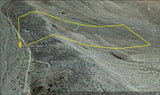
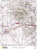
- Map of claim marked and GPS coordinates.
- Multiple maps showing claim location and surrounding areas for access.


The Geology and Stratigraphy of the Mohawk Mine
All productive mine workings on Mohawk Hill lie within the Bonanza King Formation. The Mesquite Pass thrust which marks the contact between the upper plate Cambrian Bonanza King and lower plate Devonian Sultan Formation lies 2 km east of the property. A small pod of Tapeats Quartzite (?) has been mapped in fault contact with the Bonanza King near the west edge of the mine property.

The Bonanza King consists essentially of two units; alternating thin bedded bluegray and tanwhite limestone and white dolomitic marble. Locally, a fault contact separates limestone from dolomitic marble. The Bonanza King strikes northwest and dips 2030 to the southwest (Hewett, 1956 and Evans, 1958). However, along the crest of Mohawk Hill extreme local variation in both dip angle and direction can be noted.
A small outcrop of the Clark Mountain (Cretaceous?) stock occurs along the south flank of Mohawk Hill. Its contact with the Bonanza King strikes eastwest and dips 30 to the south. Drilling indicates the intrusive is silllike, averaging 40 meters in thickness (Wiebelt, 1949). The stock was mapped by Hewett (1956) as a quartz monzonite, but thin section analysis indicates a true granite.
A massive quartz "vein" was reported by Hewett (1956) at the intrusiveBonanza King contact. The "vein" is clearly visible as a ridge of bull quartz a few meters thick trending northeast along the south flank of Mohawk Hill. Several smaller quartz veins lie to the east, wholly within the intrusive. Although the quartz vein is unmineralized at the surface, in underground workings it is locally replaced by ore mineralization. Joseph (1984) suggests that the quartz "vein" of Hewett is a skarn zone formed during intrusion of the Clark Mountain stock.

Structure
Three faults have been mapped on the mine property; all trend roughly northnortheast. The westernmost of the three faults was mapped initially by Dobbs (1961). He suggests the fault is a low angle west-to-east thrust with Tapeats Quartzite above Bonanza King. A second fault lies just to the west of the mine workings on the south slope of Mohawk Hill, its trace closely marked by the prominent quartz vein near the base of the ridge and a well defined zone of mylonitic deformation near the crest of the ridge. Both the footwall and hanging wall of the fault are Bonanza King Formation. Footwall carbonates have been weakly to moderately recrystallized to a medium grained marble. Burchfiel and Davis (1971) mapped this fault as a thrust, but more recent mapping suggests the last sense of movement on the fault was normal with the northwest side down. The easternmost fault has a nearly northsouth strike, steep dip to the west and less than 10 meters of displacement.
Ore Mineralogy and Alteration
The ore mineralogy at the Mohawk Mine is complex. Cerrusite is dominant, however smithsonite is common. Minor malachite, azurite and chrysocolla can be seen on the mine dumps. Galena and sphalerite were reported by Hewett (1956), and native silver and gold by Evans (1958). Gangue consists of abundant iron and manganese oxides in a matrix of coarselycrystalline quartz and calcite. Minor jarosite, plumbojarosite and pyrite were also noted.
Hypogene alteration consists of intense silicification, widespread recrystallization of the Bonanza King Formation and local sericitic and argillic alteration of quartz monzonite. Weathering has produced a prominent secondary gossan of iron oxides overlying the ore zone.
Ore mineralization lies within a zone of moderately to intensely silicified and recrystallized limestone and dolomite of variable thickness (210 meters). Previous workers (Joseph, 1984) have characterized this zone as a tactite or skarn adjacent to the intrusive. The only indication of the typical calcsilicate alteration associated with skarn mineralization is a small exotic block of talctremolite schist on the north side of Mohawk Hill, minor talcserpentine alteration of calcite and scattered grains of epidote and idocrase in largely unaltered Bonanza King Formation several hundred meters from the intrusive contact. Quartz monzonite adjacent to ore zones has been subjected to moderate to strong sericitic alteration and weak argillic alteration. Biotite has altered to chlorite and a mixture of iron oxides while feldspar has altered to sericite + clay.


Ivanpah Mining District
Location and History
The Ivanpah mining district is in northeastern San Bernardino County about 35 miles northeast of Baker and south of the Mountain Pass-Clark Mountain area. The district includes the mines in both the Ivanpah Range and the Mescal Range, which is just to the west. Gold mining began here at least as early as 1882, when the Mollusk mine was opened. Moderate mining activity continued in the district until about 1915, and there was some work again in the 1930s.
The first recorded mineral discovery in nearby Clark Mountain, Mescal Range and Ivanpah Mountains occurred at the Copper World mine on the southwest slope of Clark Mountain in 1868. Earlier mining occurred in 1863 at Rock Spring in the Providence Mountains, about 10 miles due south of the southern end of Ivanpah Mountains, and it has been presumed that soldiers stationed at Marl Springs, between 1867 and 1868, first worked the small gold deposits here. Although the Copper World mine was first discovered, two mines discovered in 1879, the Mescal and Bullion mines, were worked in the 1880s. The Mescal mine camp, though no more than a handfull of buildings; briefly boasted mail service. The Copper World mine languished until 1898 when it became one of the most significant copper producers in the county. With a large payroll, this camp, known as Rosalie, was also served by the U.S. Mails.

Geology and Ore Deposits
The western part of the district is underlain predominantly by limestone and dolomite, with smaller amounts of shale, sandstone and dacite. To the east is granite and gneiss, and to the south is quartz monzonite. The gold deposits are in quartz veins or mineralized breccia, which occur chiefly in granitic rocks or gneiss, although the Mollusk vein is in dolomite. Other mineral commodities in the district are silver, copper, tungsten, tin, barite, fluorspar, and rare earths. As in the Clark mining district to the north, the metal-bearing deposits are associated with several major thrust fault zones.

ACCESS:
This entire area is relatively easily accessible by dirt roads which are well marked and well maintained. A 2-wheel drive car can get to this claim off of route Route 15, but I would recommend a good 4-wheel drive or even quads to be able to access the entire claim that is not on the road.
The area is full of dirt roads, so a good map and a good GPS unit is a must, but we'll show you exactly where it is on the map as well as provide you with the precise latitude and longitude of each corner marker, so finding it will not be a problem for you.
A couple of spare tires or an air compressor and patch kit or at least a couple of cans of tire sealant is strongly recommended for obvious reasons! Also, be sure to bring in whatever water you may need, as there are almost no water sources in the area 10 months out of the year.


TO VIEW MORE PICTURE: CLICK HERE
LEGAL NOTES
A mining claim gives the holder the right to mine on mineral-rich land that belongs to the federal government.
Mining claims are a tangible asset and show proof of all interests in minerals in the area. They can be bought, sold or used as collateral, just like any other piece of real estate. A mining claim can be sold, traded, leased, gifted, willed, used as collateral or transferred in part or in its entirety just like any other real property using a quitclaim deed which is a recordable conveyance.
We offer a lifetime guarantee should the BLM take back the land.
As the largest company in the mining industry selling legitimate and valuable historic claims, you can rest assured that you are not only covered with our 100% lifetime money-back guarantee, but you can also rest easy that there is no fine print on any of our claim listings telling you will have to deal with any games like being charged phony fees or having to pay inflated “processing” or“transfer” fees. The listing price for this mine is ALL you will pay.
Our in-house legal counsel will complete all of the paperwork and documentation for recording and transferring FULL ownership of this mine into your name if you win the auction, AND we will ship you everything in one to two business days of receipt of your payment in full (usually just one day!). So you can plan to visit (and start working) your claim the next day without the lengthy delay you will experience with other companies selling claims –and you will not have to pay any extra costs, fees or other poor excuses for extra profit that normally just go into a seller’s pocket.
-PLUS-
We'll take care of all the paperwork and arrangements so you can enjoy your claim immediately after payment and we keep you informed through the entire process with confirmations when payment is received, when your paperwork has been shipped.

SHIPPING
While we cannot physically ship land to you as it doesn't quite fit into the mail box ;)
We will ship all paperwork/maps upon payment clearing we ship same business day (if payment is received by 1PM P.S.T.) We always provide tracking information so you are always informed.
