


Description
CHEROKEE RUN
CAMC313343
20 Acre Unpatented Placer Mining Claim on Federal Land in the Mineral King Mountain Mining District / Tulare County, California

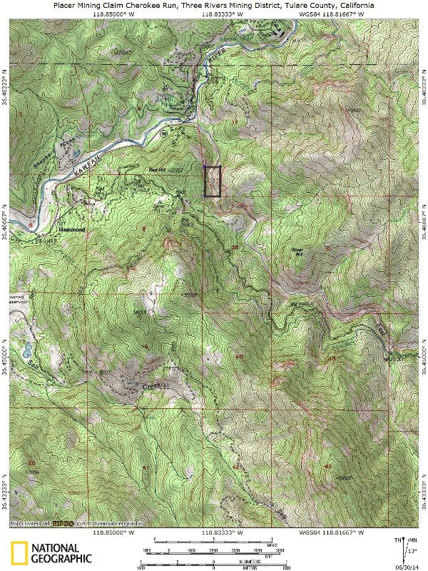
With this claim you will be getting the exclusive mineral rights to 20 acres on an excellent spot on the river for you to work. Included inside the claim is 1,649 feet of the river that you can work at your leisure.
The East Fork of the Kaweah River is a fast flowing, glacial river that runs year-round. In some spots it is as narrow as 5 feet wide – but in many the width can exceed 20 feet. Depth also varies– from a foot deep in the center to more than 8 feet in depth in some spots. Plenty of twists and turns, and lots of natural benches and gravel bars to trap the gold that is washed down every year from the subalpine glacial valley that exposes new gold for you every year.
Because the river is subject to regular flooding from the runoff seasonal storms and snowmelt, the banks will often overflow and you can often find as much gold in the surround shores as you can in the river. But the natural rock formations and constantly evolving twists and bends in the river are easy to work and provide the perfect spots to trap gold, which is heavier than the silt and sand normally carried by the flow of the river and therefore settles into numerous areas and under rocks.
There is some space for camping close to the shoreline in several spots on the river, and your are only a few miles away from the quiet and scenic town of Three Rivers, so you will have easy access to food, supplies, lodging and just about anything else you might need to enjoy your time looking for gold.


Buyer will receive the following with their completed transaction:
- Quitclaim deed showing full ownership of the claim. This will be stamped, recorded and verified with the County and the BLM offices.
- Welcome packet with all of the rules and regulations as they relate to the State and BLM where the claim is located.
- Educational documents to annually renew your mining claim with the BLM.
- A CD of all of the documented images of the claim including maps of the site.
- Map of claim marked and GPS coordinates.
- Multiple maps showing claim location and surrounding areas for access.


Historically, the valley was inhabited by the Yokut tribe of Indians, then in the 1870’s, gold and silver was discovered on the slopes of a mountain overlooking Mineral King. Mineral King Road was built in 1873 and was gradually improved throughout the early 20th century. Today, the road is in pretty good shape for sure and used by local residents, but take it slow, as it is still wild in its twists and turns, switchbacks and steep drop-offs due to rugged terrain. A proposal by Walt Disney Productions to build a ski resort in the valley in the 1960s was stopped by preservationists, and this area is still as beautiful as it was before man moved in. In 1978, the Western part of the valley became part of the Sequoia National Park and has been permanently closed for mineral entry along with the original Mineral King settlement – which you can still visit today. But there are exactly 7 claims between the park and the township – all have been claimed and there are no other areas available for claiming on the East Fork.
Mineral King Road is between a couple hundred feet and 800 feet from the water, and in some places there is several hundred feet of elevation – so know in advance that access is not easy. You will most likely have to hike in to the water with your gear from the road, but there are several roads on private land that lead down to the river, so you may be able to get permission from one of the residents to bring equipment down. We hiked in to do the survey work, and there are numerous paths and clearings to make that a little easier – but this is not a claim that you can park right next to (which is why it has never been mined out).

ABOUT THE MINING DISTRICT
MINERAL KING MINING DISTRICT, TULARE COUNTY, CA
Geography
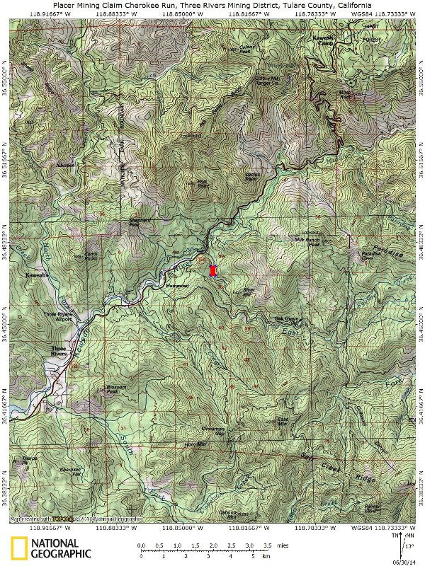
Mineral King is a 7.5-mile (12.1 km)-long, 1-mile (1.6 km)-wide glacial valley in the southern Sierra Nevada. The valley floor lies at an elevation of 7,400 feet (2,300 m), while the granite peaks rising above the head of the valley reach heights of 11,000 feet (3,400 m) or more. As the crow flies, it is located about 20 miles (32 km) southeast of Three Rivers, which is near the confluence of the East Fork Kaweah River and Middle Fork Kaweah River.
The valley floor is an expanse of open meadows with a narrow strip of riparian vegetation, including short trees and bushes, along the East Fork Kaweah River. As the flat meadows give way to rocky slopes, there are many congregations of conifers that climb the slopes to the tree line. Above the tree line, there are sheer or almost sheer granite walls that slope up to form Sawtooth Peak, Empire Mountain, Mineral Peak, Hengst Peak and others.
There are two prominent mountain passes leading out of Mineral King: Timber Gap, which leads into the Middle Fork Kaweah River drainage' and Farewell Gap at the valley head, which leads into the Kern River drainage. The first half of the valley runs from south to north and the second half runs from east to west.
Fed by snowmelt, springs and abundant lakes in granite bowls at the upstream-most section of the valley, creeks plunge down the steep valley walls as long and twisting waterfalls. These include Tufa Falls, Crystal Creek Falls, and Franklin Falls, in upstream order. This section of the valley is dotted with tributary gorges that fan out from the main canyon. Lakes in this section of the valley include the Mosquito Lakes, Eagle Lake, the Franklin Lakes, and the Crystal Lakes. From the end of the valley, the East Fork Kaweah River drops over Mineral King Falls and East Fork Falls, before continuing down a steep and narrow gorge, following Mineral King Road.
Mineral King is one of the oldest communities in the High Sierra, with many families owning cabins for six or seven generations. Many of the communities date from the 1870’s gold and silver boom and have been inhabited since.

History
Evidence suggests that Native Americans long ago used Mineral King to camp and hunt in. These Native American groups included the Wikchúmni Yokut (or Wukchumni) and the Tübatulabal. The Yokuts' main settlements actually had their main villages in the broad valley adjoining and in the present-day site of Lake Kaweah. They created summer settlements on the valley floor and also around the area that was later to be the site of Atwell Mill. The primary purpose of these summer settlements was hunting and trading with the Paiutes, who lived east of the Sierra Nevada. But prior to contact with white settlers, the valley became taboo to the Wikchúmni Yokut tribe, and no humans had inhabited it for some time.
The first explorer of European descent known to have visited Mineral King was the Irishman Harry "Parole" O'Farrell, in 1862. While employed as hunters for a trail crew building the Hockett toll trail from Visalia to Independence, O'Farrell and a Paiute companion found the valley from the south, over Farewell Gap. Attracted by the promise of mineral riches, O'Farrell returned to prospect and build a summer settlement on the East Fork of the Kaweah River, which came to be called Harry's Bend.
In the 1870’s and 1880’s, assays of precious metals in White Chief Canyon and on Empire Mountain led to the boomtown of Beulah. The first discovery of gold in the Mineral King Valley occurred in 1872, below Mineral Peak and Empire Mountain. Following the discovery, the Mineral King Wagon and Toll Road Company was established in December 1873 to build a wagon road. The first routing of Mineral King Road followed the East Fork Canyon's south side. Until then, access to Mineral King was by rough tracks. A second discovery of silver in 1878 drew more prospectors to the Mineral King area and a second Mineral King Road, following a different route up the north side of the canyon, was constructed in 1879. This created the route for much of the present-day Mineral King Road.


The Mineral King Road passes through two groves of giant sequoias, the Redwood Creek Grove and the Atwell Grove. In 1890 the groves were included in the boundaries of the newly established Sequoia National Park, encompassing the central portion of the road. Mineral King itself was excluded from the new park. The Mineral King entrance was the most heavily-used gateway to the park until 1903.
A Tom Fowler purchased the Empire Mine, then the largest mine in the area, and created the Empire Gold and Silver Mining Company. The lowermost part of the road was rebuilt in 1915 to its present-day route. Over time, the minerals were found to be difficult to extract from their ore and no significant mining ever took place, but the valley kept its hopeful name: Mineral King.
By the 1920s and as part of the Sequoia National Forest, the area became a recreational center, reinforced by the destruction of most of the mining structures in landslides following the 1906 San Francisco earthquake. Mineral King was used as a summer camping area. Continuing until 1942, private cabins were built in the Mineral King area, expanding the communities of Cabin Cove, Silver City, and Beulah. (All of these communities, including Silver City, would later become part of the National Register of Historic Places' Mineral King Road Cultural Landscape.) In 1926, Mineral King was declared the Sequoia Game Refuge by the United States Congress.

Disney's Mineral King Ski Resort was a project developed by Walt Disney and Company in the 1960’s. Disney had become interested in skiing around this time, and decided to build a ski resort in the Mineral King Valley. At the time, many skiers believed this to be the largest potential resort in all of California. Disney's bid won out over those of other developers, having the largest plans. Disney had also met renowned University of Denver and Olympic ski coach Willy Schaeffler, and together they developed the village and mountain resort plans.
Conversely, the Sierra Club supported the ski resort proposal during the embryonic stages of its development. Its original plans then were changed to a massive proposal involving the construction of 14 ski lifts, and hotels and massive parking areas. The final plan called for 27 ski lifts and facilities for 2 million visitors per year. It was at this time that the Sierra Club announced its opposition to the project. The ski resort was never built, due to environmental concerns raised by a coalition of preservationists, led by the Sierra Club. After years of legal battles between pro-development and preservationist groups, the Mineral King Valley was annexed into Sequoia National Park in 1978 by an act of Congress. That legislation effectively stopped the plan to ever develop the area into a ski resort.

Natural History
Upper Mineral King remains much like its original, natural state, while lower Mineral King has received some development. The valley is abundant in wildlife, including black bears, mule deer, yellow-bellied marmots, and some species of freshwater fish. Mining activities throughout the silver boom severely hurt the ecology of the lower East Fork below the Empire mine and White Chief Canyon, but wildlife has slowly rebounded.
Recreation
The Mineral King Valley is accessed by a long, narrow, winding mountain road that leads 25 miles (40 km) generally southeast from the junction with Highway 198 near Three Rivers. At the end of the road is the Mosquito-Eagle Trailhead, which allows hikers to access trails leading out of the south end of the valley. There are also hiking trails leading north out of the valley through Timber Gap.
There are no commercial services available in the Mineral King Valley and visitors must bring food, camping supplies, firewood and other essentials with them. None of the cabins have electricity and most use propane for lighting, cooking and fireplaces providing heat. There are a few public telephones scattered throughout the Mineral King Valley, notably at the Cold Springs campground, a trail head parking lot and at the end of the road. Cell phones do not work in the valley due to the remote location and steep terrain. There are at least two webcams that provide year-round visibility into the Mineral King Valley.
No gasoline is available after leaving State Route 198, 25 miles down the winding Mineral King road (a 90-minute drive). The National Park Service charges fees for using campsites at Cold Springs and Atwell Mill. Bears, marmots and other wild animals abound so campers take precautions to protect their food and vehicles. Suggested precautions are posted by the Park Service at the public campgrounds. Camping is not permitted in any location along the road except in the public campgrounds.

ACCESS
This entire area is relatively easily accessible by paved roads which are well marked and well maintained. Any 2-wheel drive car can get close to this river off of Mineral King Road (Via Route 198) but access to the river in most places will be by foot or private road (with permission). We'll show you exactly where it is on the map as well as provide you with the precise latitude and longitude of each corner marker, so finding your claim will not be a problem for you.


LEGAL INFORMATION
A mining claim gives the holder the right to mine on mineral-rich land that belongs to the federal government.
Mining claims are a tangible asset and show proof of all interests in minerals in the area. They can be bought, sold or used as collateral, just like any other piece of real estate. A mining claim can be sold, traded, leased, gifted, willed, used as collateral or transferred in part or in its entirety just like any other real property using a quitclaim deed which is a recordable conveyance.
We offer a lifetime guarantee should the BLM take back the land.
As the largest company in the mining industry selling legitimate and valuable historic claims, you can rest assured that you are not only covered with our 100% lifetime money-back guarantee, but you can also rest easy that there is no fine print on any of our claim listings telling you will have to deal with any games like being charged phony fees or having to pay inflated “processing” or “transfer” fees. The listing price for this mine is ALL you will pay.
SHIPPING
We'll take care of all the paperwork and arrangements so you can enjoy your claim immediately after payment and we keep you informed through the entire process with confirmations when payment is received, when your paperwork has been shipped out.

While we cannot physically ship land to you as it doesn't quite fit into the mail box ;)
We will ship all paperwork/maps upon payment clearing we ship same business day(if payment is received by 1PM P.S.T.) We always provide tracking information so you are always informed.
