


Description
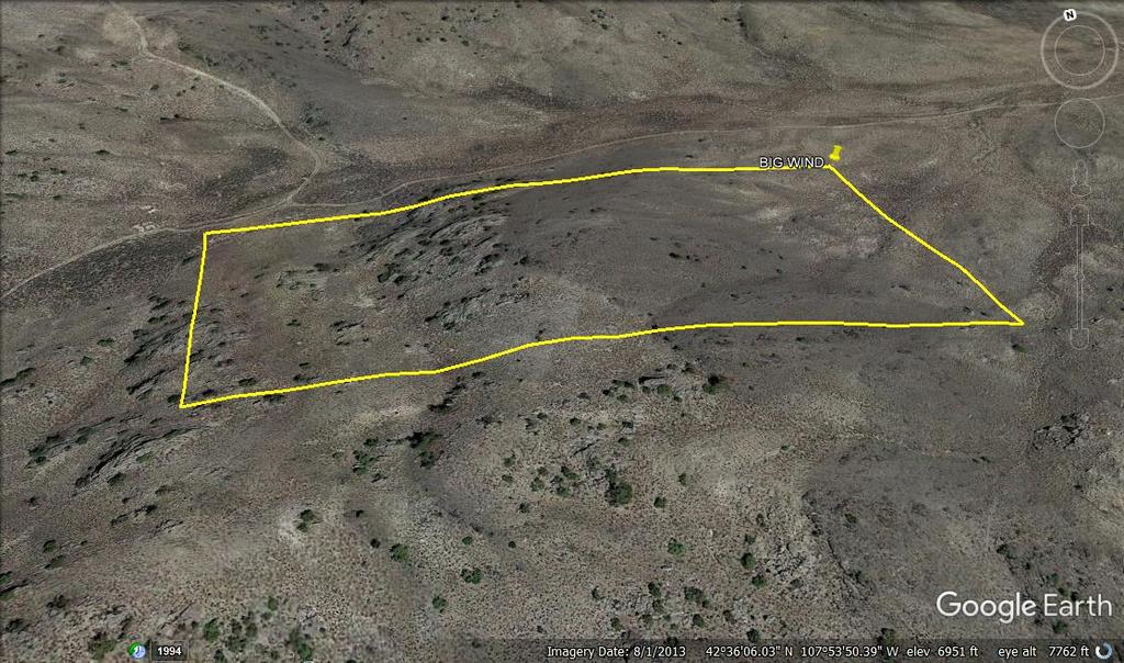
BIG WIND
WMC312576

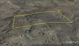
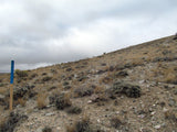
20 Acre Unpatented Placer Mining Claim on Federal Land Fremont County Wyoming
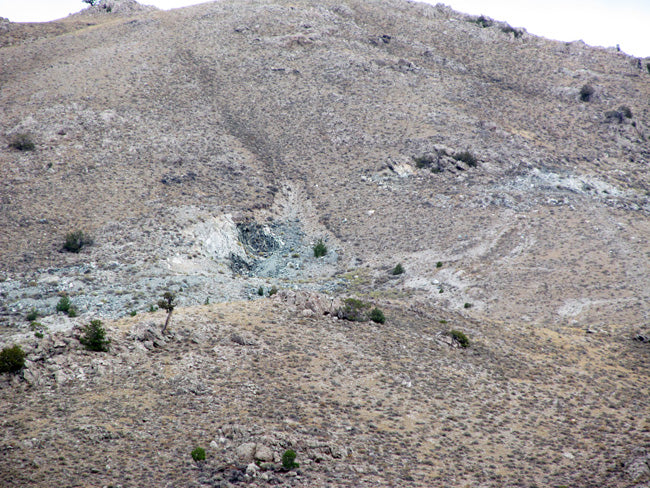
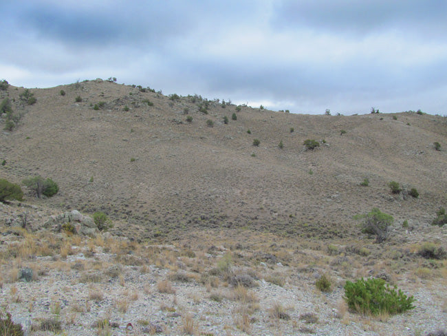
This 20-acre placer claim is located in the precious jade fields up in Big Horn / Basin Wind River mining district. The only place in the state where neprhite Jade has been identified is in the central part of the state in the granite Mountains and Crooks-Gap Green Mountain near Jeffrey City. This claim is about 8 miles from Jeffrey City.
The best jade specimens found in Wyoming are pebbles and boulders in alluvial fans and soil around Jeffrey City. Cobbles and boulders are found south of US Highway 287 (789) while jade (in place) is found in outcrops to the north of the highway in the Granite Mountains.

When prospecting for jade, note that jade boulders will ring when struck by a hammer. They feel much heavier than ordinary rocks, and are much smoother and denser than other boulders. Some boulders and cobbles of jade are so smooth that it gives an impression the stone was polished in a rock tumbler. Jade feels slightly sticky when wet and prospectors will look for a “show point,” area where the green color shows through altered rinds that encrust much detrital jade.
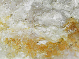
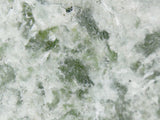
Jade is the gemologist's term for two different mineral species: nephrite and jadeite. These two minerals are nearly impossible to distinguish from one another without the aid of mineralogical and XRD (x-ray diffraction) tests. Nephrite is categorized as an amphibole and consists of extremely dense and compact fibrous tremolite-actinolite; and jadeite is categorized as a pyroxene, and also forms dense and compact material.

Many rocks are mistaken for jade. Some of the more common include rounded, stream-worn or wind-polished cobbles of amphibolite (a dark metamorphic rock that resembles dense basalt), met diabase (another dark metamorphic rock that also resembles basalt), epidotite (a dense pistachio green rock), quartzite (granular rock that can be white, dark gray, green or other colors) and serpentinite (dark green rock that can be scratched with a pocket knife). These rocks can be distinguished from jade by a couple of tests including simple field observations. For example, amphibolite and met diabase have granular texture that is lacking in most jade (jade is smooth and massive without granular texture). A freshly broken surface of quartzite will sparkle in sunlight due to the reflection of light bouncing off individual quartz grains; and epidotite has a distinct pistachio green color (unlike jade). One of the more common rocks and minerals mistaken for jade is serpentinite (a rock formed mostly of serpentine). Jade is tough and hard, whereas serpentinite is relatively soft and can be scratched with a pocket knife. In addition, serpentinite will have pockets or zones of weak to moderate magnetism that can be detected by a geologist’s magnet.

History of Jade :
The name jade comes from the time of the Spanish conquest of Central and South America where jade and jade carvings were prized as much as gold by the Aztecs. The Spanish used the name piedra de hijada, or stone of the side, because it was believed that jade cured kidney ailments when applied to the side of the body. The Spanish also called this stone kidney stone or piedros de los rinones, which translated into Latin as lapis nephriticus. The term nephrite anglicized the Latin term for jade. Nephrite has been known as ‘axe-stone’ because many nephrite stone artifacts have been found that were shaped into axe-heads due to its toughness. Although primary deposits of jade are important, much of the finest material comes from secondary alluvial deposits.

Wyoming is filled with diamonds, gemstones, gold, platinum, coal, oil, gas, rare earths, platinum, palladium and copper. It has been known as the ‘GEMSTONE STATE’.
Over the next few years, more than 40 diamond pipes and dikes were discovered – half in Wyoming and half in Colorado. Several properties were mined for diamonds including George Creek, Sloan, and Kelsey Lake. Over 130,000 diamonds were mined including gemstones larger than 28 carats. A 6.5 carat diamond was found in Wyoming and diamonds of 14 and 28 carats were mined from Colorado.

In 1981, Wyoming was unknown for gold even though all of the surrounding states had considerable gold. Gold had been discovered in Wyoming in 1842, but nothing much was ever done. Significant gold was found in the Seminoe Mountains in 1981 by a geologist from Laramie named Dan Hausel. The Rawlins Times reported a gold rush filled all of the motels in Rawlins, Saratoga, Sinclair and even Laramie with people wanting a piece of the pie. It was Timberline Minerals from Dubois who tied up the property. The company president, John Wells indicated they drilled the discovery site at Bradley Peak and picked up samples of quartz and iron formation with visible gold.

*Samples were collected and will be given to the purchaser of this claim*


* Below are microscope images of the above samples *


Buyer will receive the following with their completed transaction:
- Quitclaim deed showing full ownership of the claim. This will be stamped, recorded and verified with the County and the BLM offices.
- Welcome packet with all of the rules and regulations as they relate to the State and BLM where the claim is located.
- Educational documents to annually renew your mining claim with the BLM.
- A CD of all of the documented images of the claim including maps of the site.
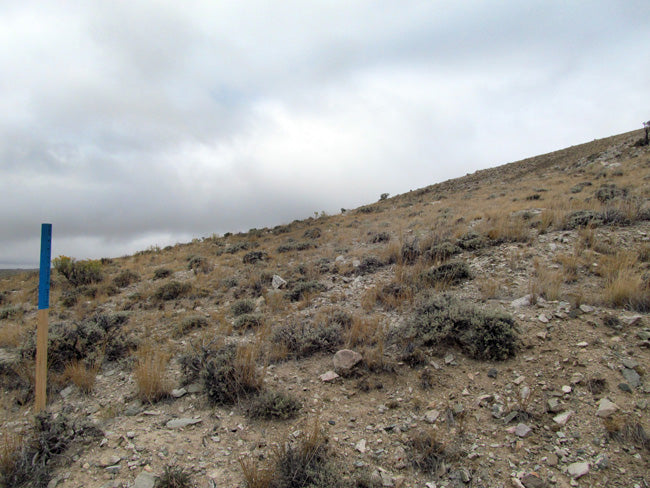
- Map of claim marked and GPS coordinates.
- Multiple maps showing claim location and surrounding areas for access.
CAMPING:

ABOUT THE MINING DISTRICT
Fremont County was created in 1884. It is the historical home of the Wind River Indian Reservation, home of the Shoshone and Arapaho tribes of Native Americans. It included Park, Big Horn, and Hot Springs counties until 1890 when they split. It was named for General John Charles Fremont, who was a surveyor and explorer searching for a route to the Pacific Ocean in 1842. His group of 20 men were guided by Kit Carson and Enos, a Shoshone Indian.
South Pass, a break in the continental divide, is also located in Fremont County. Indians had been using the pass for centuries before Robert Stuart and his group were the first whites to cross the pass October 12, 1812. The first horse drawn wagons to cross the pass were led by Captain Benjamin Bonneville in 1832. Gold was discovered here in 1842. The big boom came in 1867 when the Carissa mine (Named for Clarissa Whitney who is thought to be the first white child born in Wyoming), Miner Delight, and Burr mines were discovered, producing millions of dollars in gold. Over 5,000 people came to the area during this time to search for gold.
Fremont County produces more than half of the uranium in Wyoming, which is second in the United States in uranium production. Jade also found in Fremont County which is the Wyoming State gem stone.
Gold was discovered about 25 miles south of Lander in 1842, but mining did not begin seriously until at least the early part of 1870. There are many placers, but lode gold has been the most important. Some authorities credit the area with about 90,000 ounces of gold. It is an area where local inquiry could be very important in finding gold.

CLIMATE -
Fremont County, Wyoming, gets 9 inches of rain per year. The US average is 37. Snowfall is 42 inches. The average US city gets 25 inches of snow per year. The number of days with any measurable precipitation is 47.
On average, there are 235 sunny days per year in Fremont County, Wyoming. The July high is around 85 degrees. The January low is 10. Our comfort index, which is based on humidity during the hot months, is a 66 out of 100, where higher is more comfortable. The US average on the comfort index is 44.
TEMPERATURE –
Because of its elevation, Wyoming has a relatively cool climate. Above the 6,000 feet level the temperature rarely exceeds 100° F. The warmest parts of the State are the lower portions of portions of the Big Horn Basin, the lower elevations of the central and northeast portions, and along the east border. The highest recorded temperature was 114° F on July 12, 1900, at Basin in the Big Horn Basin.
The average maximum temperature at Basin in July is 92° F. For most of the State, mean maximum temperatures in July range between 85 and 95° F. With increasing elevation, average values drop rapidly. A few places in the mountains at about the 9,000 - foot level have average maximums in July close to 70° F. Summer nights are almost invariably cool, even though daytime readings may be quite high at times. For most places away from the mountains, the mean minimum temperature in July ranges from 50 to 60 ° F. Of course, the mountains and high valleys are much cooler with average lows in the middle of the summer in the 30s and 40s with occasional drops below freezing.
In the winter time, it is characteristic to have rapid and frequent changes between mild and cold spells. Usually there are less than 10 cold waves during a winter, and frequently less than half that number for most of the State. The majority of cold waves move southward on the east side of the Divide. Sometimes only the northeast part of the State is affected by the cold air as it slides eastward over the plains. Many of the cold waves are not accompanied by enough snow to cause severe conditions. In January, the coldest month generally, man minimum temperatures range mostly from 5 to 10° F. In the western valleys mean values go down to about 5° below zero. The record low for the State is -66° F observed February 9, 1933, at Yellowstone Park. During warm spells in the winter, nighttime temperatures frequently remain above freezing. Chinooks, warm down slope winds, are common along the eastern slopes.

ACCESS
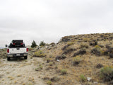
These are the two major roads that lead up to the claim. Before you head to the claim, make sure you check the road conditions. WY-28 E – good road conditions, might be some strong winds US-287 S – good road conditions, dry, beware of strong winds. Once you reach Graham Road, you will be off the main highway and on a dirt road. This drive is fairly easy with two-wheel capability; but you might need some extra traction or even go for a four-wheel drive once you reach the last 2,800 feet till the claim.
There is plenty of room on the claim to part your vehicle(s) or even a small camper for equipment. You will notice a different dirt road going in to the claim that you have access to as well.


OTHER THINGS OF INTEREST:
- Sightseeing - spectacular views of the surrounding Wyoming landscape are easy to find.
- Hunting - outstanding deer and elk hunting.
- Rock Hounding - jade and agate are found in surrounding areas.
- Wild horses - can be seen in and around the area year-round.
- Fishing - brook trout fishing in the east fork of Cottonwood Creek at Cottonwood Campground.
- Mountain Biking - ride the Green Mountain loop road with a side trip to Wild Horse Point. Begin at U.S. Highway 287 and ride the entire loop road-approximately 31 miles. A trip to Wild Horse Point is eight miles one-way from Cottonwood Campground.
- Fremont County Picnic Area - located on the west loop of Green Mountain Road.

LEGAL NOTES
A mining claim gives the holder the right to mine on mineral-rich land that belongs to the federal government.
Mining claims are a tangible asset and show proof of all interests in minerals in the area. They can be bought, sold or used as collateral, just like any other piece of real estate. A mining claim can be sold, traded, leased, gifted, willed, used as collateral or transferred in part or in its entirety just like any other real property using a quitclaim deed which is a recordable conveyance.
We offer a lifetime guarantee should the BLM take back the land.
As the largest company in the mining industry selling legitimate and valuable historic claims, you can rest assured that you are not only covered with our 100% lifetime money-back guarantee, but you can also rest easy that there is no fine print on any of our claim listings telling you will have to deal with any games like being charged phony fees or having to pay inflated “processing” or “transfer” fees. The final price for this mine is ALL you will pay.
Our in-house legal counsel will complete all of the paperwork and documentation for recording and transferring FULL ownership of this mine into your name if you win the auction, AND we will ship you everything in one to two business days of receipt of your payment in full (usually just one day!). So you can plan to visit (and start working) your claim the next day without the lengthy delay you will experience with other companies selling claims –and you will not have to pay any extra costs, fees or other poor excuses for extra profit that normally just go into a seller’s pocket.
-PLUS-
We'll take care of all the paperwork and arrangements so you can enjoy your claim immediately after payment and we keep you informed through the entire process with confirmations when payment is received, when your paperwork has been shipped.

While we cannot physically ship land to you as it doesn't quite fit into the mail box ;)
We will ship all paperwork/maps upon payment clearing we ship same business day (if payment is received by 1PM P.S.T.) We always provide tracking information so you are always informed.
