


Description
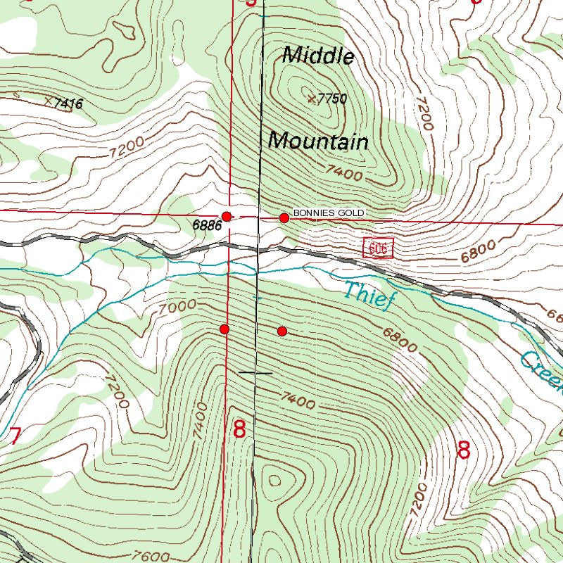
BONNIES GOLD
MMC234436

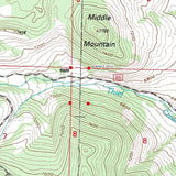
20 Acre Unpatented Placer Mining Claim on Federal Land Montana
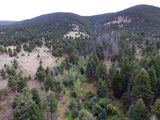
This placer gold mine totals over 704 feet of creek. With this claim you will be getting the exclusive mineral rights on an excellent spot on the creek for you to work at your leisure.
Commodities (Major) - Gold Deposit
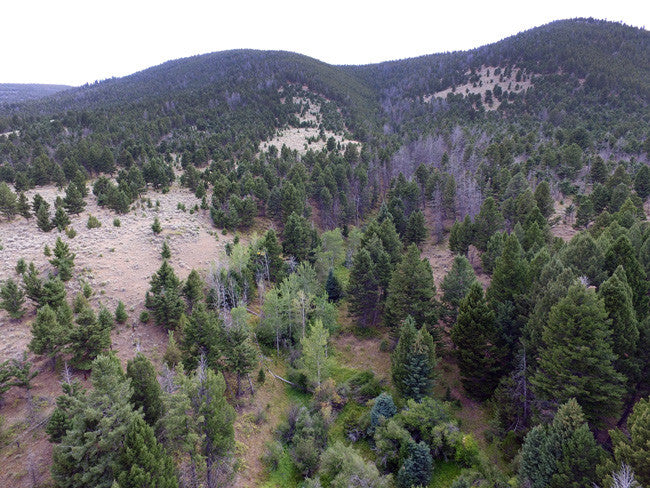
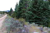
Access: Thief Creek in Montana is located in a historic town and is 2WD accessible. The road ranges anywhere from 20-60 ft. from the creek, making it easily accessible. There are many flat surfaces to park and set up camp leading up to the claim, and although some areas are a bit overgrown, they can be cleared out with a machete.

Acres: 10
Type: Placer
Mining District: Utopia Mining District
County: Beaverhead

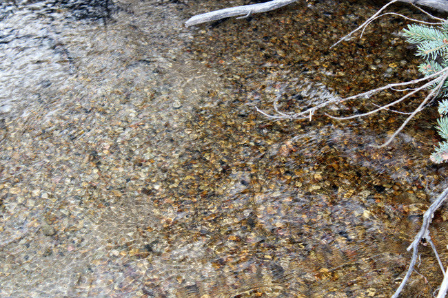
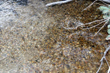
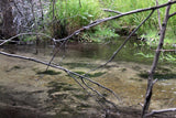
Thief Creek has vibrant colors and has a depth ranging between 8-30 inches and can reach anywhere between 2-12 ft. wide.
The Montana law states that rivers and streams capable of recreational use may be so used by the public regardless of streambed ownership. It also states that certain activities require landowner permission.
Because the law affects your rights and responsibilities as a landowner or recreationist, the information that follows may be of interest to you may want to look into the "Stream Access in Montana Brochure"
Recreational mining must adhere to closures and restrictions indicated in the Instream Mining Stream Classification list.


Buyer will receive the following with their completed transaction:
- Quitclaim deed showing full ownership of the claim. This will be stamped, recorded and verified with the County and the BLM offices.
- Welcome packet with all of the rules and regulations as they relate to the State and BLM where the claim is located.
- Educational documents to annually renew your mining claim with the BLM.
- A CD of all of the documented images of the claim including maps of the site.
- Map of claim marked and GPS coordinates.
- Multiple maps showing claim location and surrounding areas for access.

Nearby Lodging and Camping Facilities

Along the way make sure to notice the mining adit (a surface opening to a mine) and the old miner's cabin.' The trail returns to the Center through a riparian area along Thief Creek, where you can see evidence of several resident moose. The Stream Trail begins on the north side of the Center and drops down into the riparian area along Thief Creek. It ends at the Birch Creek Guard Station, a log cabin built in the late 1930s and now available for overnight rental. From here the Pond Trail begins and follows Birch Creek to a pond built by the CCCs in the 1930s. The trail continues to the Aspen Picnic Area. As you walk the trail, look for evidence, still visible, of sudden flooding caused by the failure of an upstream dam in the 1920s.The Range Trail connects the end of the Pond Trail near the Aspen Picnic Area to the end of the Forest Trail.


Any activity that would alter the stream bed or stream bank (i.e. dredging, sluicing, sniping, gold panning, hand tools used to move sediment around, or any type of placer mining) will require a “310” permit from the local county (Beaverhead County). This permit may be needed even if the Forest Service considers the work “Notice of Intent” level or less such as panning with pick and shovel, hand sluicing, etc. A good place to start with questions on 310 permits is the local conservation district or the MT Fish, Wildlife, Parks biologist for that area, Matt Jaeger.
A second state permit is needed for any activities with a wastewater discharge. This is called a Montana Pollutant Discharge Elimination System (MPDES) Permit. This may or may not apply, depending on what the activity is. If it can be done without discharge, you don’t need this permit. If there is any discharge, the permit will be needed.
There are two categories of MPDES permits, “General” Permits and “Individual” Permits. General Permits are given for certain categories of activities, one of which is “recreational” suction dredging. You can look at Montana’s Recreational Suction Dredging Guidelines to see what restrictions/closures MDEQ has under this General Permit. If someone proposed placer mining discharge not associated with a suction dredge, then an “Individual” MPDES Permit would be necessary. If ground water or surface water is to be used, then a water right from the State would be needed. There is a good information page and contact information here. For more information visit Beaverhead-Deerlodge National Forest website.
Under the Montana Stream Access Law, the public may use rivers and streams for recreational purposes up to the ordinary high-water mark. Although the law gives recreationists the right to use rivers and streams for water-related recreation, it does not allow them to enter posted lands bordering those streams or to cross private lands to gain access to streams.
House Bill 190, passed during the 2009 Legislative Session, confirmed that the public has access to surface waters by public bridge or county road right-of-way. The Department, in cooperation with the affected landowner and county, is responsible for providing public passage around or through a fence preventing such access. A typical access feature would be a stile, gate, roller, walkover, or wooden rail fence. ( http://fwp.mt.gov/fishing/guide/access/streamAccess.html )


ABOUT THE MINING DISTRICT
The geology of this district indicates that sedimentary rocks are in contact with an intrusive batholith of monozonitic type. The intrusive mass extends into the mountains on the northwest and the upturned sedimentary rocks rest in unconformity upon it, striking northeast and dipping southeast. Mines with copper ore, such as the Indian Queen, tend to be northeast of the creek while the magenetite ores are found south of the creek (Winchell 1914). The Indian Queen Mine is on the contact between the quartz monzonite and the Paleozoic limestones. The monozonite is cut by aplitic dikes and the ore occurs in irregular shoots and bunches in the fault or in the limestone near the contact. Ore is predominantly from the oxidize zone and includes native copper, malachite, azurite, chrysocolla, cuprite, melaconite. Sulphide ores include chalcocite, bornite, and chalcopyrite. The gangue is made up primarily of quartz, calcite, hematite, garnet, epidote, diopside and axinite (Winchell 1914). http://deq.mt.gov/Land/AbandonedMines/linkdocs/26tech

The district was discovered not long after the influx of miners into the region in 1862 and 1863 caused by the opening of the rich placer mines at Bannock and Virginia City, but for years it was not developed, because mines yielding principally copper were then too far from smelters and from markets to be of much importance. Progress in the development of the district was very slow; a few shafts of a maximum depth of about 100 feet were sunk and a few tons of ore were shipped for testing purposes at various times during the later sixties and the seventies. Even the advent of a railroad within about 6 miles of the district in 1882 caused no marked activity for several years. Finally, about the close of the century, the Beaverhead Mining & Smelting Co. opened the Indian Queen mine. Previous development work was directed largely to opening the Greenwich and Treasury claims, about 2 miles northeast of the Copper Queen, in the foothills overlooking the Beaverhead Valley, and not directly on Birch Creek. Early in 1903 the company installed a 50-ton blast furnace which produced 990,000 pounds of copper matte and metal in 1903 of a net value of $57,600, and 770,000 pounds in 1904 of a net value of $40,000. https://pubs.usgs.gov/bul/0574/report.pdf


LEGAL NOTES
We offer a lifetime guarantee should the BLM take back the land.
As the largest company in the mining industry selling legitimate and valuable historic claims, you can rest assured that you are not only covered with our 100% lifetime money-back guarantee, but you can also rest easy that there is no fine print on any of our claim listings telling you will have to deal with any games like being charged phony fees or having to pay inflated “processing” or “transfer” fees. The final price for this mine is ALL you will pay.
Our in-house legal counsel will complete all of the paperwork and documentation for recording and transferring FULL ownership of this mine into your name if you win the auction, AND we will ship you everything in one to two business days of receipt of your payment in full (usually just one day!). So you can plan to visit (and start working) your claim the next day without the lengthy delay you will experience with other companies selling claims –and you will not have to pay any extra costs, fees or other poor excuses for extra profit that normally just go into a seller’s pocket.
-PLUS-
We'll take care of all the paperwork and arrangements so you can enjoy your claim immediately after payment and we keep you informed through the entire process with confirmations when payment is received, when your paperwork has been shipped.

While we cannot physically ship land to you as it doesn't quite fit into the mail box ;)
We will ship all paperwork/maps upon payment clearing we ship same business day (if payment is received by 1PM P.S.T.) We always provide tracking information so you are always informed.
