


Description
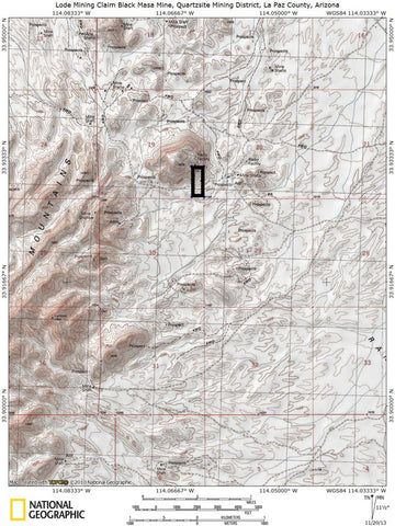
BLACK MESA
AMC441157
Extremely hard to find and valuable Quartzsite, AZ mining claim. Double mine, TONS of tailings onsite and easy access via two-wheel drive.

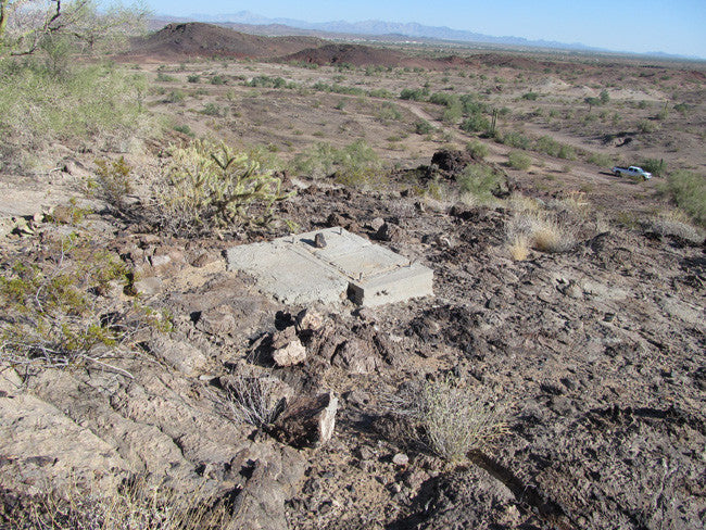
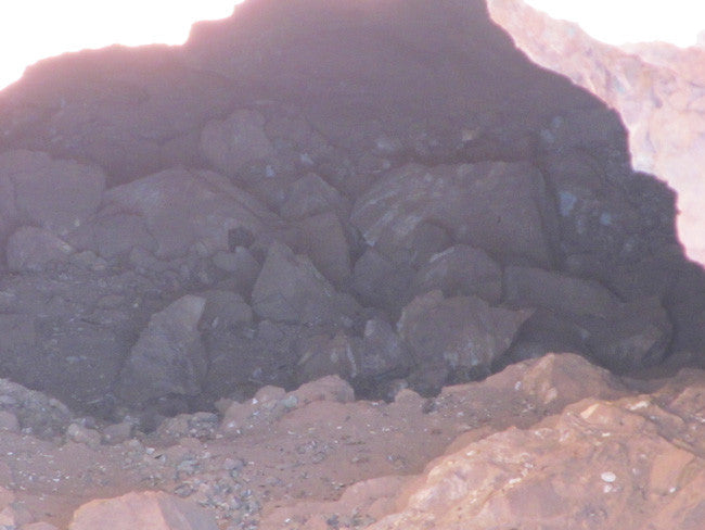
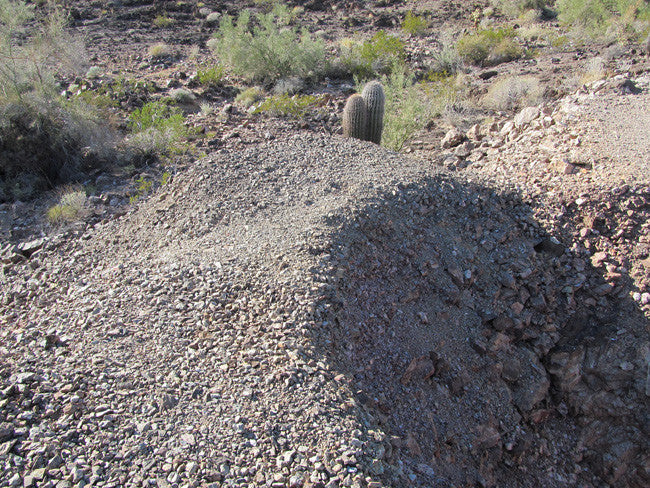
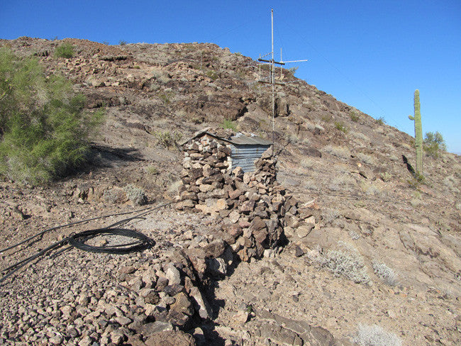
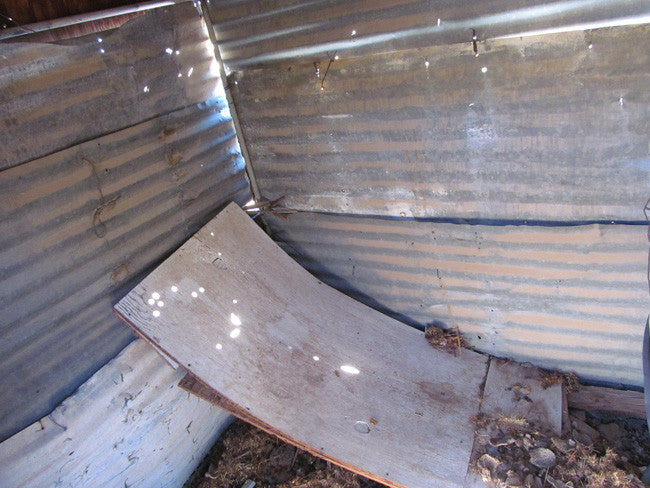
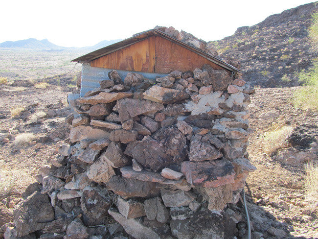
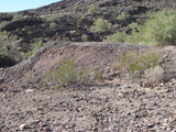
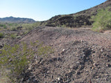
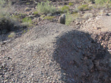
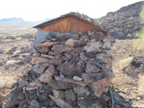
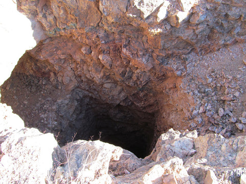
This mine is pretty interesting. Nearby, just over the boundary line of this claim (and not included in the claim) is some kind of antenna farm and a small shack that probably housed radio equipment at one time. Looks to be at least 30+ years old. I included pictures so you could see it – but it is not on the claim. A few feet to the west though, where the claim begins, there is a ton of rich volcanic rock/tailings. And a little further to the west is the double mine.


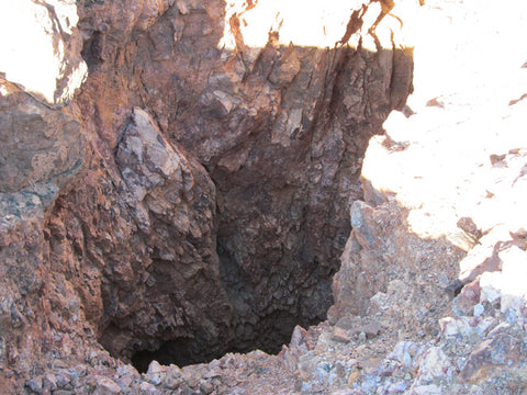
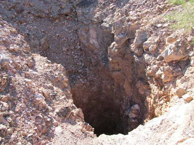
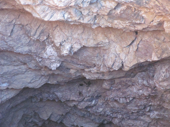
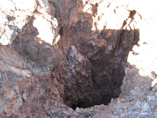
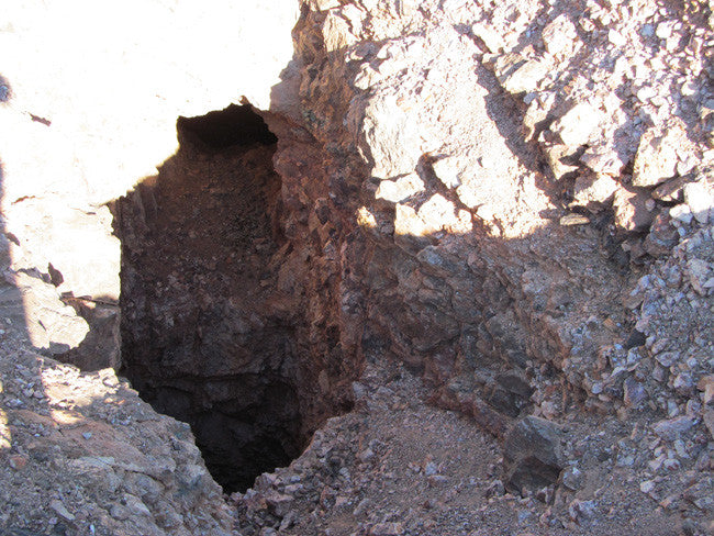
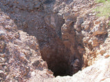
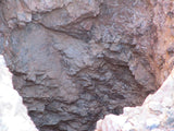
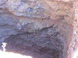
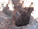
Consisting of a shaft with an adit/tunnel branching off to the north at about 20 feet of depth and roughly 60 feet of depth to what is probably another level of horizontal drifting/adit (can’t tell for sure because the sides are too steep and there is a lot of loose rock on the edge). Play it safe with this one and rope up for sure before exploring. Looks to be some extensive workings based on the size of the tailings onsite, and the exposed vein runs for a good 4o feet on the surface, so plenty of rich ground to work.

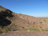
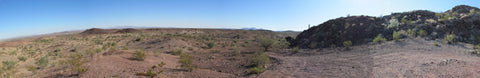
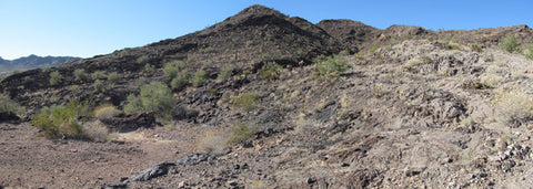
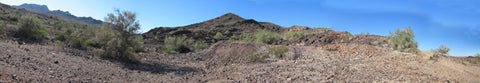
Numerous dry washes, prospects and open cuts cover this claim all over – plenty of places to dry wash or sluice if you bring in your own water source. The famous placers and lodes that surround the town of Quartzsite are known to have been successfully worked by individual prospectors since the 1860's and it continues to this day. Gold deposits are found in the Dome Rock Mountains west of Quartzsite, in the Plomosa Mountains east of Quartzsite and scattered on the La Posa Plain which lies in between the two ranges. Both mountain ranges are highly mineralized and contain numerous lode mines bearing many different types of valuable ore.


National Bureau of Mines Registered and recorded. Quite literally one of only a handful of chances to own an important part of the rich Quartzsite mining history in a truly historic mining area!!


Buyer will receive the following with their completed transaction:
- Quit Claim deed showing full ownership of the claim. This will be stamped, recorded and verified with the County and the BLM offices.
- Welcome packet with all of the rules and regulations as they relate to the State and BLM where the claim is located.
- Educational documents to annually renew your mining claim with the BLM.
- A CD of all of the documented images of the claim including maps of the site.
- Map of claim marked and GPS coordinates.
- Multiple maps showing claim location and surrounding areas for access.
ABOUT THE MINING DISTRICT
QUARTZSITE ARIZONA MINING INFORMATION
District Overview
Geography
The topography of southwestern Arizona is characterized by small detached, generally northward-trending mountain ranges separated by broad aggraded desert plains. Quartzsite lies in the broad basin of Tyson Wash at the northern end of La Posa plain, in southwestern Arizona, between the Plomosa Mountains on the east and the Dome Rock Mountains on the west, at an elevation of about 850 feet. The distance between .the Plomosa and Dome Rock Mountains at the narrowest part of the plain is probably not less than 6 miles. Quartzsite is in the west-central part of Yuma County
Most of the mountains in this region attain elevations not exceeding 2,000 feet above the surrounding desert. Ferrar Peak, 2,900 feet high, is the highest elevation near Quartzsite. The two small outlying ridges north of Tyson Wash rise not more than 800 feet above the surrounding bench lands, but the average relief is less than 500 feet. Gravel and wash covered bench lands slope gently westward from the Dome Rock Mountains nearly to Colorado River, where usually there is an abrupt descent of 100 feet to the river bottom lands.
Many shallow arroyos or washes drain to Colorado River, but none of them carries surface waters. Of these, Tyson Wash and Arroyo La Paz are the most prominent. Tyson Wash, with a length of 50 miles, heads south and west of Quartzsite in several branches, which unite and drain northward to the north end of the Dome Rock
Mountains, where the channel turns sharply westward and debouches on the Colorado River bottom lands. Tyson Wash carries an underground water flow at Quartzsite, where small tracts are irrigated from shallow wells operated by windmills or small gasoline pumps. Arroyo La Paz heads in the Dome Rock Mountains and for most of its course forms the southern boundary of the Colorado River Indian Reservation. The water supply in the vicinity of the placer camps is very scanty.
Water of a rather inferior quality is furnished by Gonzales well, near the reservation line, and a small or uncertain supply is obtained from " tanks " or holes eroded in the bedrock of arroyos. Of these, Goodman tank is the best known and most accessible, but even this water must be piped from depths of several feet from the sands that fill the excavation. The placers in the Plomosa Mountains were supplied with water through pipe lines leading from the wells near Quartzsite.
Climate
The climate of the region is extremely arid. The mean annual precipitation at Parker, near the north end of the mining district, is only 4.27 inches, and the mean annual temperature for a period of 12 years is 70.9° Fahrenheit. The summer is intensely hot, and work in the open is difficult, but the winter is delightful. The vegetation of the region is scanty and includes no trees suitable for use as mining timber. The bottom lands of Colorado River support good growths of willow and mesquite and a few cottonwoods; in the larger arroyos there are sparser growths of thorny shrubs, including ironwood, ocotillo, palo verde, and mesquite; and on the bench lands and hill slopes there are several varieties of cactus and small shrubs.
Geology
Igneous and sedimentary rocks in complex association compose these mountains, and they range from pre-Cambrian schists and gneisses to Tertiary or Quaternary volcanic rocks. The placer areas specifically examined in the Dome Rock Mountains and in that part of the Plomosa Mountains here referred, to are composed of intrusive igneous rocks, some of which are of schistose structure and others of holocrystalline granitic texture. The ages of these rocks could not be determined from the geologic evidence nearby, although the schist is believed to be of pre-Cambrian age and the granite much younger and probably of Mesozoic age.
The ridges north of Tyson Wash are composed of intermixed schistose sedimentary and igneous rocks, into Avhich are intruded narrow dikes of basic rocks, dikes and irregular masses of pegmatite and aplite, and an area of granite similar to that in the La Paz district. The metamorphosed sedimentary and igneous rocks are not differentiated in the general area.The rocks of sedimentary origin range from fine-grained silvery-white sericite schists to coarse-grained biotite schists with interbedded thin marble beds.
Granite gneiss, amphibolite schist, quartz-epidote schist, and granite comprise the larger igneous masses in these ridges. Lava flows of Tertiary and Quaternary age occur throughout the eastern part of the Plomosa Mountains a short distance east of the area.
Brief Mining History
Placer mining in this part of Arizona closely followed the discovery of the La Paz diggings. Part of the early history of these workings, in addition to that given by Mr. W. W. McCoy, was obtained from the report of J. Ross Browne in "Mineral resources of the States and Territories west of the Rocky Mountains," published in 1868.
In January, 1862, Capt. Pauline Weaver was trapping along Colorado River, and at times would stray off into the mountains on prospecting trips for gold. The Indians, with whom he was on friendly terms, gave him some nuggets and, after Weaver had organized a party from Yuma, conducted him to the source of the gold. The party picked up $8,000 in nuggets within a short time, but had to return to Yuma, 150 miles distant, for provisions.
A rush from southern California and Arizona points immediately started for these placers, and within a short time hundreds of miners were prospecting the country around the original location.
The auriferous quartz veins in the vicinity of the La Paz diggings were probably discovered at the same time as the placers, for in places they form conspicuous outcrops with abundant float. The decomposition of these veins has produced the placer gold for the largest areas of gold-bearing wash are found along the more persistent quartz veins on which mining has been done.
These veins are generally distributed through the metamorphosed pre-Cambrian igneous and sedimentary rocks, although they are more numerous in the country rock of the La Paz placers than in the sedimentary schists. The veins are of two types those that lie in the planes of schistosity and those that cut across them.


ACCESS
This entire area is relatively easily accessible by dirt roads which are well marked and well maintained.
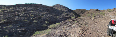
The area is full of dirt roads, so a good map and a good GPS unit is a must, but we'll show you exactly where it is on the map as well as provide you with the precise latitude and longitude of each corner marker, so finding it will not be a problem for you.
I advise caution whenever driving or hiking on this claim – the entire valley is dotted with abandoned mines – most of them are easy to see from a distance, but some of them are impossible to see until you are right on top of them. I would estimate that only 20% of them are roped or fenced off – the rest are wide open and you should be extremely careful if entering them.
A couple of spare tires or an air compressor and patch kit or at least a couple of cans of tire sealant is strongly recommended for obvious reasons! Also, be sure to bring in whatever water you may need, as there are almost no water sources in the area 10 months out of the year.


Legal Notes
A mining claim gives the holder the right to mine on mineral-rich land that belongs to the federal government.
Mining claims are a tangible asset and show proof of all interests in minerals in the area. They can be bought, sold or used as collateral, just like any other piece of real estate. A mining claim can be sold, traded, leased, gifted, willed, used as collateral or transferred in part or in its entirety just like any other real property using a quitclaim deed which is a recordable conveyance.
We offer a lifetime guarantee should the BLM take back the land.
As the largest company in the mining industry selling legitimate and valuable historic claims, you can rest assured that you are not only covered with our 100% lifetime money-back guarantee, but you can also rest easy that there is no fine print on any of our claim listings telling you will have to deal with any games like being charged phony fees or having to pay inflated “processing” or “transfer” fees. The listing price for this mine is ALL you will pay.
Our in-house legal counsel will complete all of the paperwork and documentation for recording and transferring FULL ownership of this mine into your name if you win the auction, AND we will send you everything in one to two business days of receipt of your payment in full (usually just one day!). So you can plan to visit (and start working) your claim the next day without the lengthy delay you will experience with other companies selling claims –and you will not have to pay any extra costs, fees or other poor excuses for extra profit that normally just go into a seller’s pocket.
-PLUS-
We'll take care of all the paperwork and arrangements so you can enjoy your claim immediately after payment and we keep you informed through the entire process with confirmations when payment is received, when your paperwork has been shipped out.
Shipping
While we cannot physically ship land to you as it doesn't quite fit into the mail box ;)
We will ship all paperwork/maps upon payment clearing we ship same business day (if payment is received by 1PM P.S.T.) We always provide tracking information so you are always informed.
